

MAINE, USA — Sunday morning snow:
It was a pretty gloomy Saturday for most. We melted a good bit of snow over the last couple days, but it's time we turn back toward a more wintry feel and introduce a few flakes to Maine.
Snow showers are still passing through Maine. This is not a blockbuster system. In fact, most Mainers only get a couple inches out of it.
We knew this from the start-- it's a pretty weak and fast storm. That's exactly what we've observed thus far.
Snow continues to fall overnight and into Sunday morning. As temperatures keep falling, it means snow is more likely to stick.
Church services and other Sunday morning activities will be mostly unimpeded by these snow showers. Slick roads are in the cards, though, so prepare accordingly.


This timeline outlines when we are most likely to deal with those slick conditions. Falling temperatures Sunday night into Monday will favor black ice, too, though any treated surfaces will be in better shape later on Sunday than they are after the fresh snow Sunday morning.


The storm departs quickly on Sunday. In its wake, partly cloudy skies and gusty conditions. With those northwest winds, it'll definitely feel fairly chilly outside.
Expect a handful of snow showers Monday. Impacts will be minimal as these are just scattered light showers that roll through. A quieter day is on the way Tuesday.
Wednesday Snow Potential:
Another storm threat lingers in the middle of the week.
There's still a lot of variability in this storm, but it's worth talking about.
We know that a storm will likely form over the ocean. This is going to result in some unsettled weather for Maine.
RELATED: Weekend Mountain Report: 01-04-2020
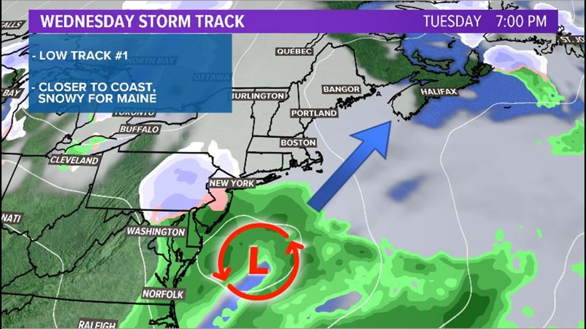
The low could take two tracks, though.
A track closer to the coastline would favor snow in Maine. Since the set up for the storm is a bit more impressive than the weekend system, it could mean at least a few inches for most of the state.
A track further out to sea could result some snow showers, but much lower snow totals.


The general model spread still favors at least some measurable snowfall. The chart below is from the GEFS, the American ensemble forecast system. It is centered in Bangor but the theme represents most of Maine.

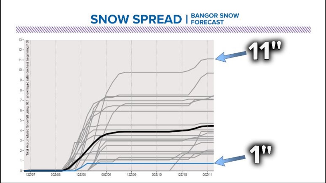
Ensemble models take the same starting point with minor perturbations to show range of outcomes. In other words, it shows the spread for forecast snowfall in Bangor. It is immensely helpful in picking out where the trends are and also lets us know if the models are showing agreement in the forecast or not.
As noted above, the deterministic run of the GFS (in blue) only has about an inch of accumulation.
The highest total for Bangor, which includes a little bit of extra accumulation late next week, is closer to a foot.
The thick black line averages everything out. This suggests the mean from the ensemble forecast favors accumulating snow. In other words, when you take all the possible solutions and put them together, the forecast looks like we'll see some snow.
Bottom line for Wednesday:
Snow is absolutely still a possibility, even though models have backed off for one run. We need to watch closely over the next day or so.
We've got a lot of time before we get to Wednesday. It could take another day or so to really work out the complexities of this storm system. Until then, Ryan will have you covered with an update Sunday morning, and I'll be back to deep dive this on Sunday night.
