
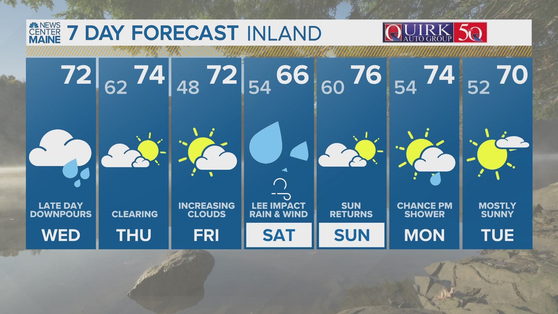
PORTLAND, Maine — Hurricane Lee remains in the open Atlantic Ocean about 450 miles south of Bermuda, as a Category 3 with winds at 115 miles per hour, as of 5 a.m. Wednesday. Lee is moving north very slowly at about 6 miles per hour. The storm isn't expected to gain additional strength and will gradually weaken to a Category 1 hurricane as it approaches New England waters.
The National Hurricane Center has shifted the track a little to the west, closer to Maine. This brings more of an impact to the Maine coastline (especially Downeast) and the rest of the state too.


Before we move on, it's important to note that Lee will be rapidly weakening as it moves through the Gulf of Maine. The cold ocean water will zap it, weakening it to a Nor'easter type storm by the time it makes landfall. I say this so people don't freak out. This will NOT be like a Gulf Coast landfall. Utter destruction will NOT occur, so the worst case scenario is OFF the table.
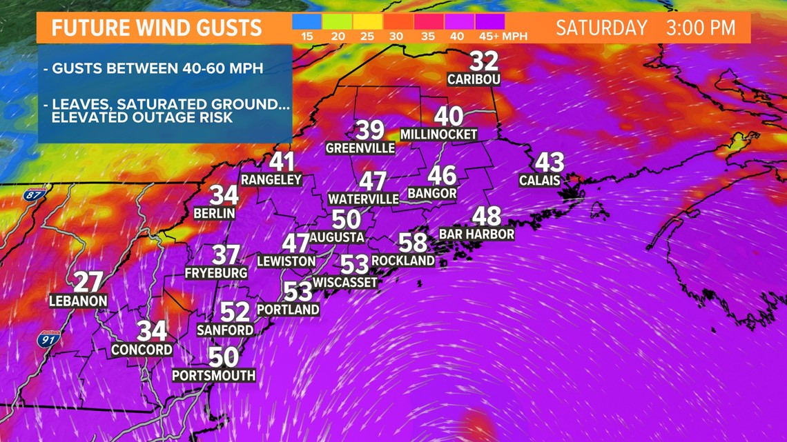
With all that said, a closer track means we will have issues from inland flooding, power outages, and beach erosion. The magnitude of these impacts is what we will be zeroing in on over the next few days.


Our threshold for power outages will be much lower than from a winter Nor'easter when leaves are off trees and the ground is frozen solid, cementing in root systems. Leaves add weight and act like sails, and our soil is saturated. I'd guess that gusts around 40 or 45 mph may be that line when outages begin to occur. At this time, I'm expecting gusts between 40-60 mph, so obviously people are going to lose power ... how many is still up in the air. There is also a chance that a section of Downeast Maine could receive gusts higher than 60 mph, but this is highly track dependent and won't be known until we get closer.

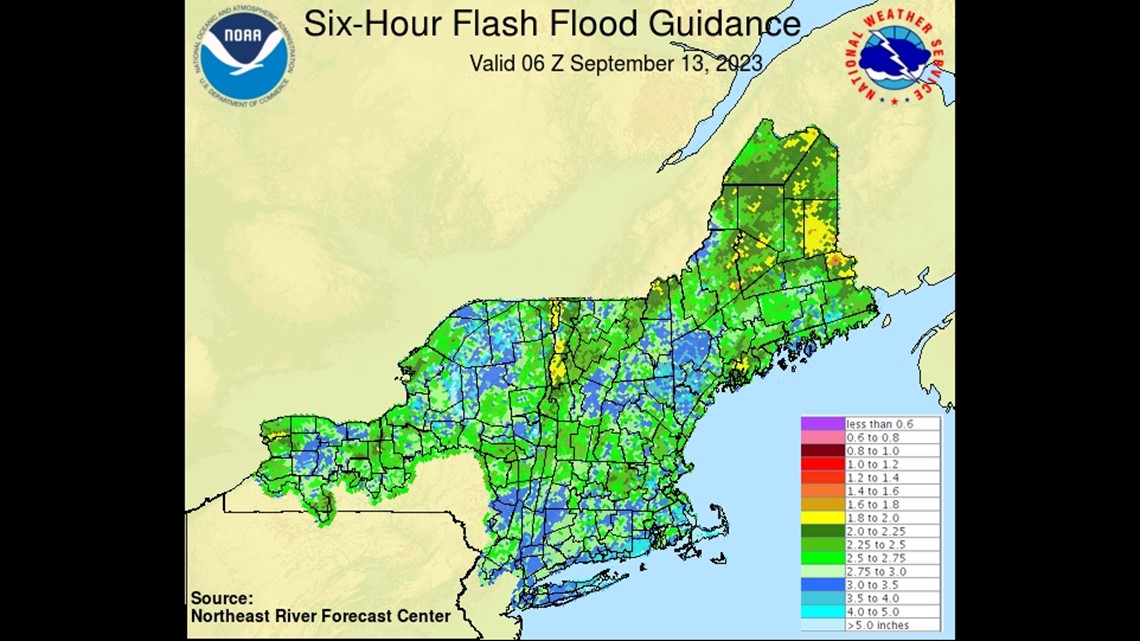
Rain will play a role too. Looking at flash flood guidance, many areas of the state, because of the wet summer, can only hold about 2 to 3 inches of rain over a 6 hour period. Many tropical systems are capable of much more rain than that, including this one. With it's current track, 2-4 inches of rain is not out of the question and that means inland, freshwater flooding will be a problem. Storm drains will get backed up, rivers will rise, and basements may get wet.

It's looking like our coastline is going to get battered. Some of the waves within the Gulf of Maine may be 20 feet or higher. Many of those will be breaking on our coastline and beaches. This is going to result in beach erosion and it could be fairly significant for some of our beaches too.


This track is not set in stone yet and may wobble a little left or right over the next couple of days. Keep checking back for the latest. Small shifts can result in big impact changes.
For the latest breaking news, weather, and traffic alerts, download the NEWS CENTER Maine mobile app.
RELATED: NEWS CENTER Maine Weather Forecast