
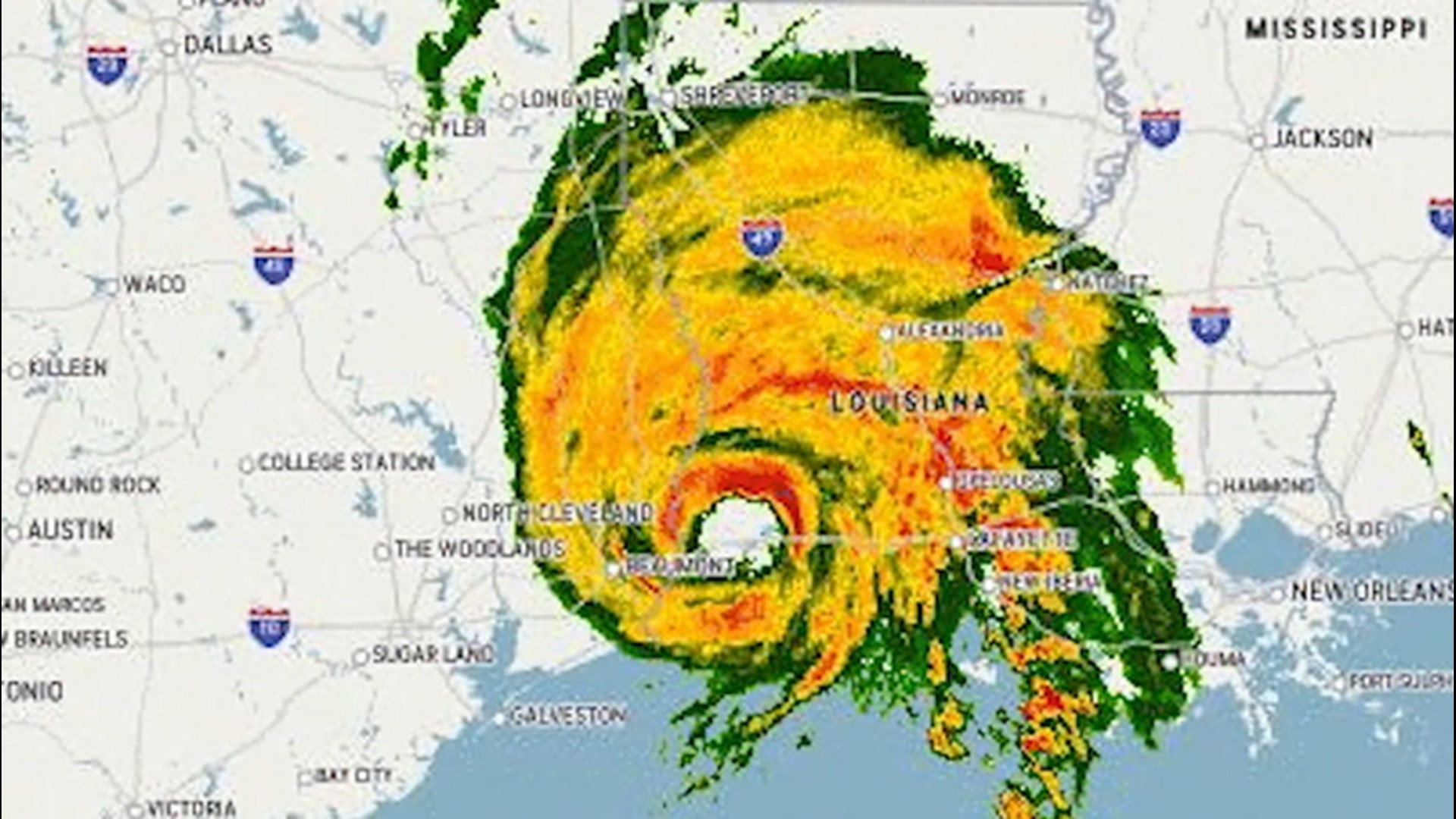
With the dissipation of former Hurricane Laura, the tropical Atlantic settled down over this past weekend, but there are already new areas of trouble, and one is fairly close to the East Coast of the United States. This disturbance could become the next tropical storm of the already busy and record-setting 2020 hurricane season.
A disturbance moving along a cold front in the southeastern U.S. is one of two areas with a high chance of developing into a tropical depression or storm this week.
This front is part of the same system that absorbed Tropical Rainstorm Laura after it helped to fuel areas of heavy rain and severe thunderstorms across the Northeast on Saturday.
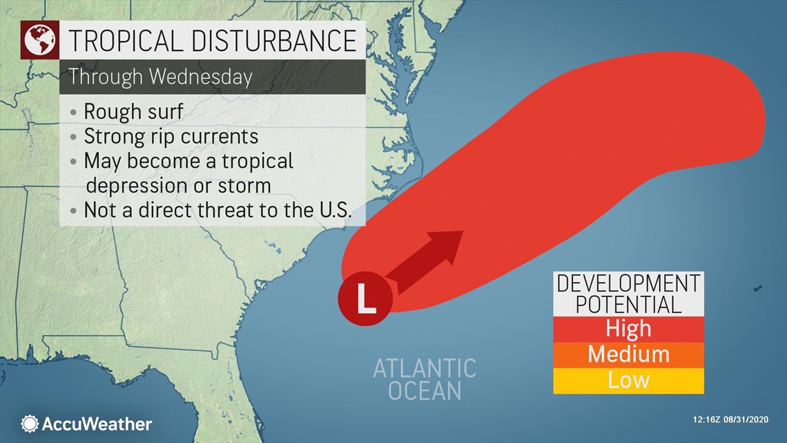
This tropical disturbance emerged off of the coast of northern Florida early in the day on Sunday and is forecast to move into an area of low wind shear and warm water as it tracks from just off the Carolina coast to north of Bermuda through Wednesday.
"This feature is expected to become better organized and can develop into a tropical depression at any time through Wednesday as it passes between the East Coast and Bermuda," AccuWeather Senior Meteorologist Adam Douty said.

The next name on the list of tropical storms for the 2020 Atlantic hurricane season is Nana. However, there will be competition for the N-named storm, due to a budding system in the Caribbean. Following Nana, Omar is the designated "O" name for this season.
Since landfall in the U.S. is not expected with the feature sitting off the Carolina coast, impacts will be indirect but perhaps still significant in nature.
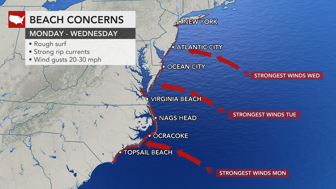
The greatest risk will be to bathers and boaters along the East Coast and Bermuda. In the U.S. an easterly flow of air, created by the tropical feature and an area of high pressure over New England, will push ocean water westward. In addition to stiff breezes, rough surf and frequent and strong rip currents are in store, especially from the Carolinas to Long Island, regardless of development.

Through the second half of the week, the storm is forecast to track to the northeast into the northern Atlantic Ocean. If a non-tropical storm system is able to pull this tropical feature farther north, it could bring impacts to Atlantic Canada late this week.
"Other than an increase in surf and showers along the Carolina coast on Monday and Tuesday, this does not appear to be a significant threat to the United States," stated Douty.
Another area being monitored for tropical development is a tropical wave, or disturbance, that moved into the eastern Caribbean on Saturday. That feature could compete for a name with the system near the U.S., and the Caribbean system will send heavy rain and the risk of life-threatening mudslides and flash flooding into part of Central America later this week.
Elsewhere in the Atlantic, there are multiple disturbances that have moved off the coast of Africa or will do so in the coming days this week.

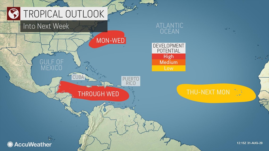
The chance of development with these features in the southeastern part of the basin are low in the short-term, but conditions may allow for development as they drift westward in the coming days.
September is typically the busiest month for tropical storm development, and the peak date for tropical activity is usually around Sept. 10. Over the past 100 years on this date, there have been more than 90 active named storms.
The 2020 season has already produced 13 named storms, which is not only well ahead of the average pace, but also in record territory, even surpassing the infamous 2005 season. The year 2005 brought devastating storms, including Katrina, Rita and Wilma. This year, Cristobal and all the storms from Edouard through Marco set early-season formation records for their respective letters.
With Tropical Storms Nana and Omar both potentially forming this week, both could set early-season formation records. Nate holds the early formation record for the "N"-named storm on Sept. 5, 2005, and Ophelia holds the early formation record for the "O"-named storm on Sept. 7, 2005.
Seven named systems have made landfall in the continental U.S. this year -- a new record for the end of August. Laura's landfall on Aug. 27, broke previous records set in 1886 and 1916 when six storms struck the continental U.S. through the end of August, according to Colorado State University Meteorologist Phil Klotzbach. In addition to Laura, Marco, Isaias, Hanna, Fay, Cristobal and Bertha all made landfall this year.
Additional landfalls are likely in the U.S. prior to the end of the 2020 Atlantic hurricane season. AccuWeather meteorologists, led by hurricane expert Dan Kottlowski, predicted up to 10 landfalls in the U.S. this season in what is expected to be an extremely active peak hurricane season.