
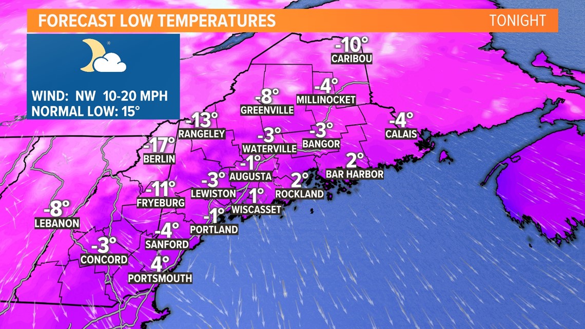
MAINE, USA — It is just brutal out there this morning! As I'm writing this, some parts of Maine have wind chill values below -40°F.
Wind gusts themselves have been consistently between 35 and 45 mph. This has caused some power outages, which may actually increase a little more through the morning.
On the bright side, the wind will relax a bit through the afternoon. Winds will even go calm overnight tonight, so crews should have plenty of time beginning later today to get everything fixed up.
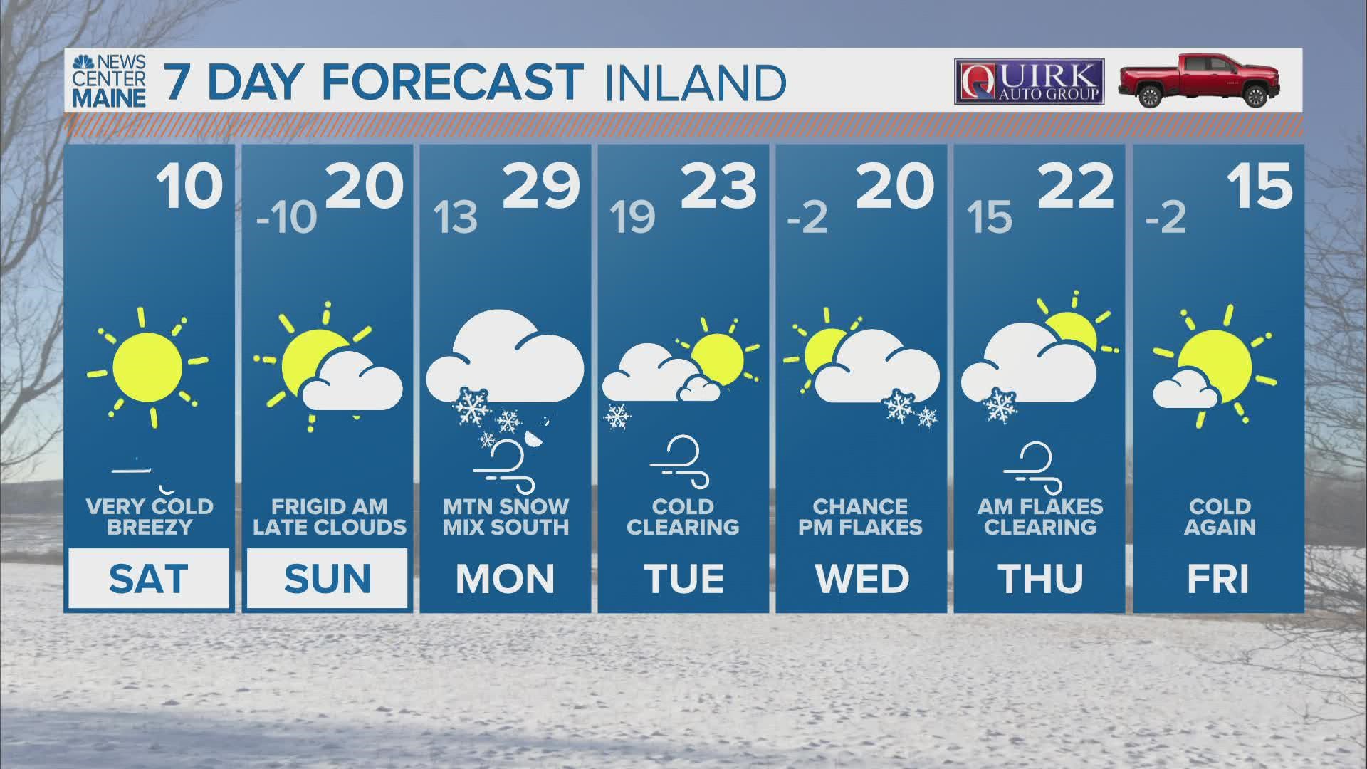
Once we get through the bitter cold, the focus will shift to Monday's impactful winter storm.

Sunday starts off on a bitter note. With less wind than Saturday, it may not feel as cold, despite air temperatures actually being lower.
In the afternoon, temperatures will top out near 20° under sunny skies.

Clouds quickly build in out ahead of Monday's storm on Sunday evening. Precip will hold off until Monday morning, though.

All week long, I spoke about the possibility of two storm tracks for Monday's storm.
With all of the data I have now, I am feeling pretty confident in a track that takes the storm inland a bit. This complicates the forecast, as a burst of heavy snow in the morning will eventually change over to rain across the coastline with some mixing inland.
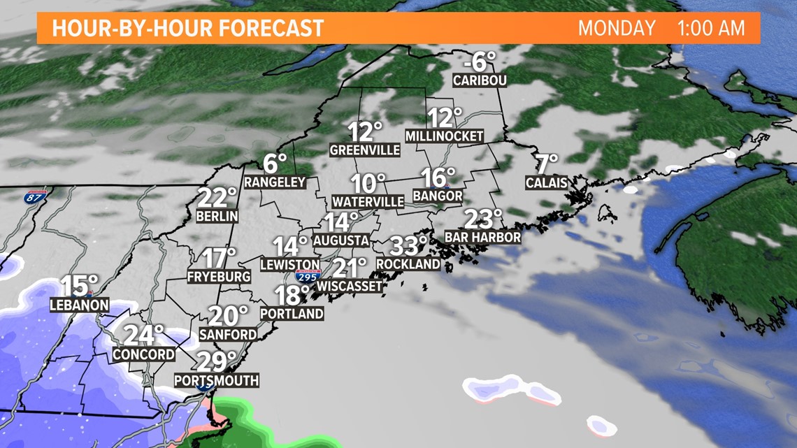
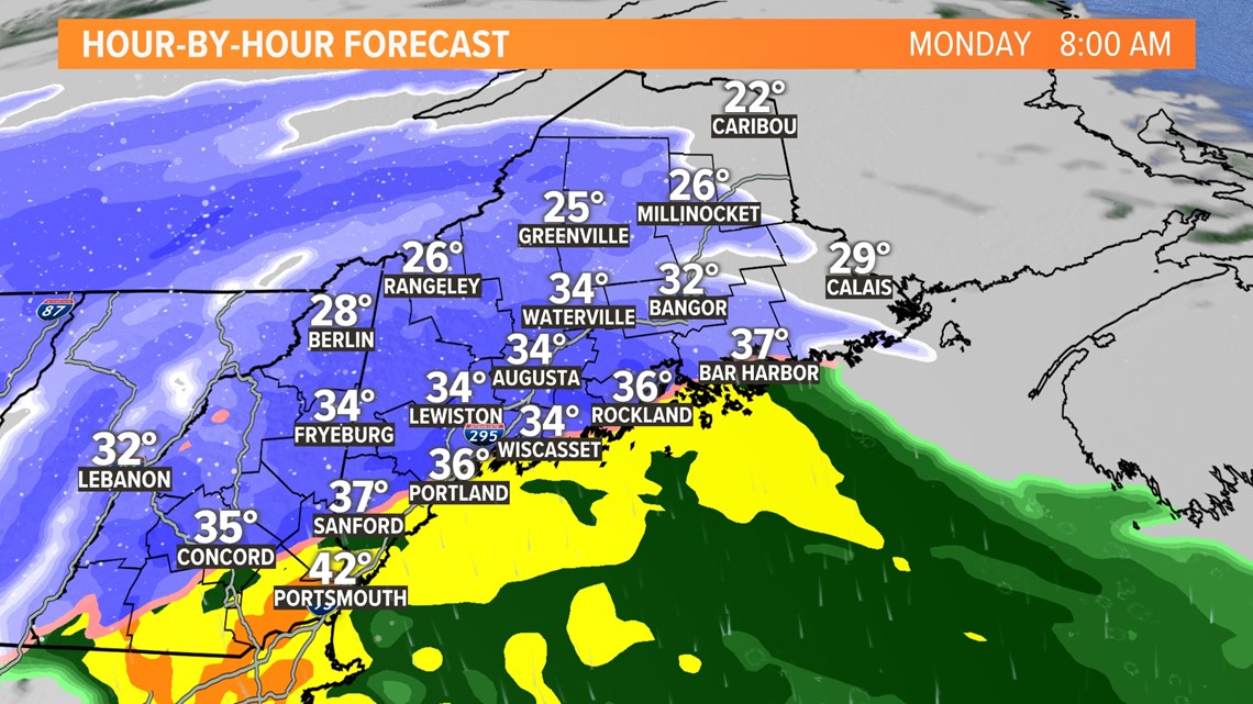
Take a look at Monday morning. Even as early as 8 a.m., coastal temperatures will be trying to get above freezing. I think this model is a little too fast, though. I expect sub-freezing temps for all of Maine and New Hampshire through the morning.

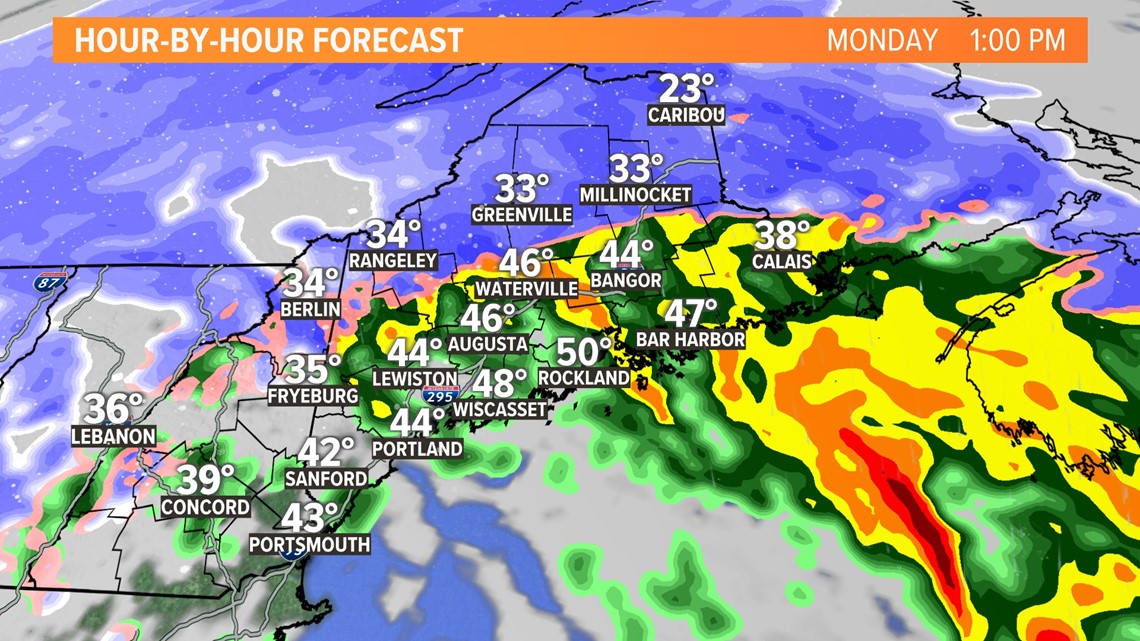
The warm does eventually win, though. Even here, I think it's too fast. Expect the foothills to stay mostly snow. Bangor will, however, likely see a shift to rain.
So, just how much snow will this drop?

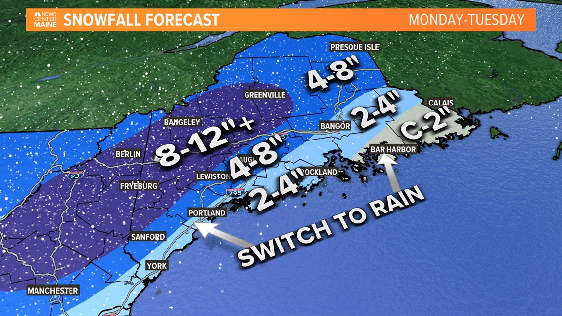
Here's what I am thinking for totals. The highest chance at seeing a foot is across the foothills of western Maine. The ski areas could really use something like this, so it's a good thing for a lot of people who depend on winter weather for a living.
The corridor from Sanford to Augusta will see a bit of heavy snow before a bit of mix or even rain takes over. Given the temperature profiles, it might end up as sleet or freezing rain.
Should there be any icing, this is the spot to watch.
I think that central Maine will also probably deal with some wet, heavy snow. This might cause additional stress on trees and powerlines, so watch for potential outages.
At the coastline, snow gives way to rain. While snow totals will be lower here, impacts are still going to be felt from this storm. Those impacts come from potentially strong wind gusts.

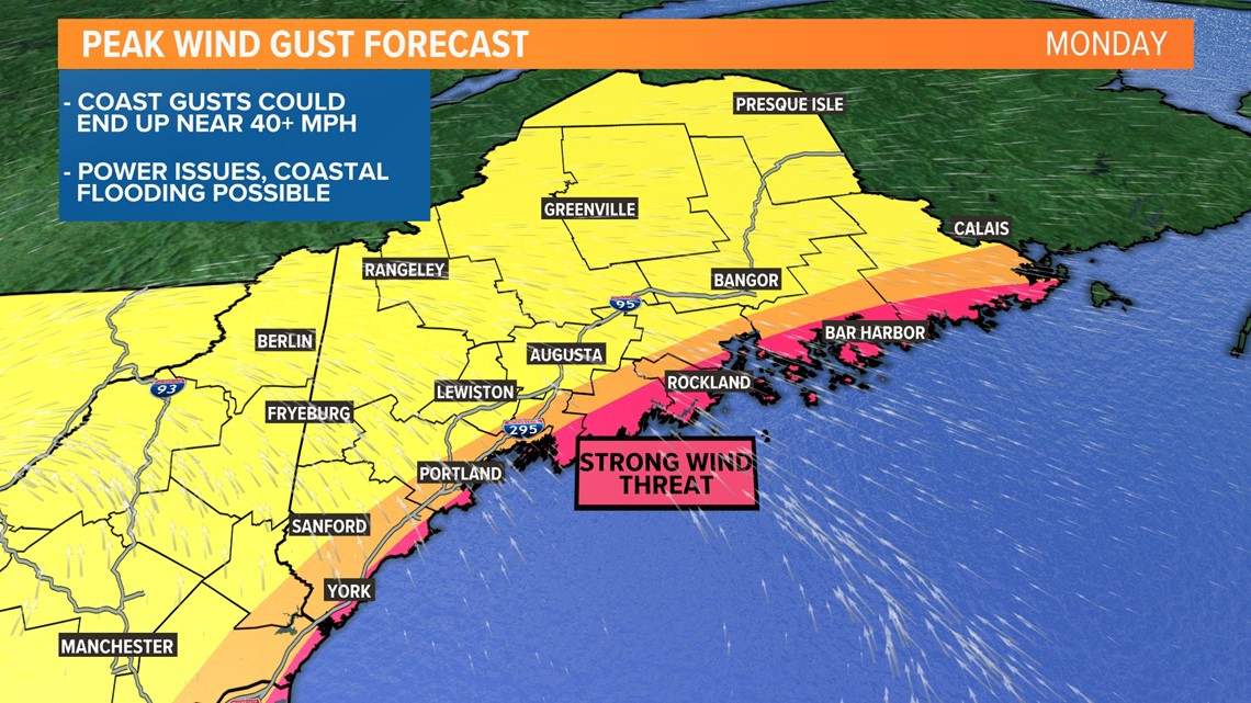
Given the current forecast, wind gusts pick up on Monday in the morning and afternoon, especially along the coastline.
Gusts could approach or exceed 40 mph out of the south. Widespread power outages seem unlikely, but there will still probably be some issues that pop up.
I am a little more concerned for areas near I-95. With some wind gusts and a heavy, wet snow, there might be a few more power issues that pop up here. We're still fine-tuning the forecast and will have updates as soon as they're available.
Last, but certainly not least, is the potential for some minor coastal flooding. Given the southerly wind direction, some flood prone areas along the coast could see inundation around high tide.
Here's your quick breakdown:
What
An impactful winter storm rolls through on Monday. Snow, wind gusts, and some minor coastal flooding are all on the table.
Timing
Snow begins around sunrise Monday in western Maine, an hour or so after sunrise in eastern Maine.
Snow will fall in the mountains the whole day. At the coast, snow will switch to rain by the early afternoon. In between, expect some mixing to develop.
The entire storm wraps up late Monday with some lingering flakes into Tuesday morning.
Impacts
Tough travel is the biggest impact. Watch for slick roads, low visibility, and maybe some debris in the roads.
Power outages are also an issue, specifically near the coastline. Wind gusts and some heavy, wet snow will stress trees and powerlines. I still am not expecting widespread issues at this time.
Minor coastal flooding will be possible during the high tide cycles on Monday.
I know the timeline details are still a little muddy, but I am waiting until tomorrow to nail down specifics (switch to rain, switch to sleet, etc). Keep an eye out for that blog.
- Mike Slifer, @MikeSliferWX
RELATED: NEWS CENTER Maine Weather Forecast